


stevenson4

ARVIEU
User

Length
24 km

Max alt
1421 m

Uphill gradient
750 m
Km-Effort
35 km

Min alt
573 m

Downhill gradient
1044 m
Boucle
No
Creation date :
2024-02-12 17:51:42.566
Updated on :
2024-02-12 17:53:27.597
6h00
Difficulty : Medium

FREE GPS app for hiking
 SityTrail
IGN / Geographical institutes
SityTrail Plus
The world is yours!
About
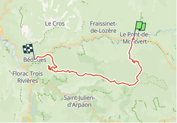
Trail Walking of 24 km to be discovered at Occitania, Lozère, Pont de Montvert - Sud Mont Lozère. This trail is proposed by ARVIEU.
Positioning
Country:
France
Region :
Occitania
Department/Province :
Lozère
Municipality :
Pont de Montvert - Sud Mont Lozère
Location:
Unknown
Start:(Dec)
Start:(UTM)
559248 ; 4912533 (31T) N.
Comments